ROMAN EMPIRE
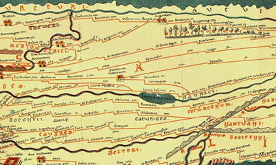 Image: Map of Roman roads in the “Tabula Peutingeriana” (edition by Konrad Miller, 1887, based on a Medieval copy of a Roman street map from the second half of the fourth century)
The Romans colonised the central Rhineland region until approximately 440 AD, in order to extend the Roman Empire further northwards. For transportation, they not only used the river; they also constructed important routes on land. An important example of this was the Roman Rhine Valley Road, which is today the B9, between Bonn and Remagen. Designed as a long-distance route, it ran from Milan, across the Alps to Cologne and then on to the North Sea. Roman towns and settlements were built along it.
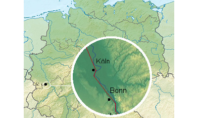 Image: Map of the layout of the limes between Cologne and Remagen
In the Roman province of Germania Inferior, the Lower Germanic Limes ran along the Rhine for a distance of 385 kilometres. It was intended to mark the border from Remagen all the way to Katwijk an Zee and to secure it against hostile Germania. The wide river deterred attackers, meaning that the Romans did not have to build any ramparts. Today, the limes is an example of a common, cross-border past. NRW, Rhineland-Palatinate and the Netherlands aim to have it designated a UNESCO World Heritage Site. More information can be found at http://www.roemer-welt.de/Limes-Infozentrum/Limes-Region/
French occupation
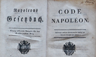 Image: Napoleon’s book of statutes, Düsseldorf, 1810. Siebengebirgsmuseum / Heimatverein Siebengebirge, Königswinter
Napoleon’s conquest of the areas to the west of the Rhine brought significant changes: the Rhineland became French and the Rhine became the border. The advances brought about by the revolution and modern ideas found their way to the Rhineland. In 1804, the “Code Civil” (later also known as the “Code Napoléon”) was imposed; it governed civil law and remained in effect in the Rhineland until the German Civil Code was introduced in 1900.
Kingdom of Prussia
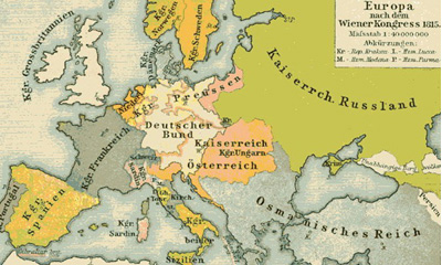 Europe after the Congress of Vienna, 1815, historical atlas, 1911
After the defeat of Napoleon as a consequence of the Battle of Leipzig in October 1813, the victorious powers convened the Congress of Vienna in 1814–15, in order to redraw the map of Europe in favour of the Kings and Princes. Westphalia and the Rhineland were ceded to the Kingdom of Prussia. The vast majority of the territory today known as North Rhine-Westphalia therefore became Prussian and was unified again politically for the first time since the fall of the Carolingian Empire.
Bridge at Remagen
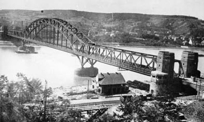 Image: Bridge before its destruction
The Ludendorff bridge across the Rhine was immortalised as “The Bridge at Remagen”. Built for military purposes during the First World War, the German armed forces wanted to destroy it in 1945 to prevent the allies from crossing the river. The attempt to blow up the bridge failed, the Americans advanced further and crossed the Rhine for the first time at this point. On 17th March 1945, the bridge collapsed as a result of the unsuccessful detonation attempts and intensive battles. The American war film “The Bridge at Remagen” (1969) made it famous throughout the world.
The former bridge’s tower, which still exists today on the west side of the Rhine, houses the Peace Museum Bridge at Remagen
> Website
More information on the history of the Rhine and of the Siebengebirge can be found at the Siebengebirgsmuseum Königswinter, Kellerstraße 16
Tue–Fri 2 PM–5 PM, Sat 2 PM–6 PM, Sun 11 AM–6 PM, Mondays closed > Website