 Image: View of the Siebengebirge, 1853 (idealised view from the west)
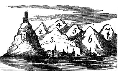
There are many explanations for how the Siebengebirge got its name. One of these establishes a connection between the number seven and the many hills. In German, the word for seven was, for a long period of time, identical with a large amount or an abundance. This is evident in sayings such as “Ein Buch mit sieben Siegeln”, which literally translates as “A book with seven seals” and means “a mystery” or a “closed book”. As early as 1570, the Latin term “Septem Montes” was mentioned in the records. The more than 40 hilltops on the Rhine were too many to count, therefore “seven” was chosen to denote a large group.
Flora and fauna
 Image: Hirschzungenfarn (hart's-tongue fern), Wikipedia / Christian Fischer
Thanks to its forested areas, quarry piles and V-shaped valleys, the Siebengebirge is a favourable habitat for a diverse range of species of flora and fauna. This includes rare animals, such as the red kite and the kingfisher, as well as endangered plants like the hart’s-tongue fern. It is a protected species and feels particularly at home on the damp, steep slopes of forests with soil rich in lime and with trees such as ash, maple and lime.
 Image: Bronze plaque, European Diploma
Since 1971, the Siebengebirge has regularly been awarded the “European Diploma”. It is given to protected areas which are of European importance due to their exceptional landscape and biological and geological features.
Altar and transportation route
 Image: Altar, “Nightingale Valley” (wikipedia, Karsten Ratzke)
In the summer of 1925, celebrations were held in Königswinter to commemorate “one thousand years of the German Empire”. A festival procession congregated at the new altar in “Nightingale Valley” for an outdoor church service in the forest. In doing so, the citizens of the Rhineland, who at the time were subject to French military administration, commemorated that in 925 King Henry I had annexed the region and incorporated it into his East Francia. It only gradually became a “German empire”, thus the “one thousand years of the German Empire” claim was not completely historically correct. The actual motivation for the Rhinelanders was to put on a display of confrontational patriotism after defeat in the First World War. A historical path for transporting stone can still be discerned today at the wayside cross next to the altar.
Ofenkaulen
As early as the 14th century, the Drachenfels burgraves quarried tuff for oven stone in the Siebengebirge. Tuff can be found throughout the Siebengebirge; however only at a few places, such as the “Ofenkaulen”, is the tuff so homogeneous and of such high quality that it was possible to quarry oven slabs from it. The “Ofenkaulen” are a system of tunnels (mines) about two kilometres to the east of this location. The Ofenkaul hill, on the southern side of the Mirbesbach valley opposite the Nonnenstromberg, is named after the tunnels. Trachyte tuff is homogenised, compacted ash which was conveyed to the Siebengebirge during the main tertiary volcanic phase approximately 23.5 million years ago.
 Image: Mine layout, oven stone mine, Rings, source: www.klaus-bloemeke.de
The stone was mined underground in individual tracts that were run by various owners from the end of the 18th century
 Image: www.kuladig.de
Today the “Ofenkaulen” are a registered historical site. Entry to the mines is forbidden and, due to unsecured outflows and the risk of collapse, it is also extremely dangerous.
The Siebengebirgsmuseum exhibits original documents concerning the millennium celebration - including a documentary (black-and-white, silent) on the Königswinter festivities in June 1925. Siebengebirgsmuseum Königswinter
> Website
Visit the permanent exhibition on the history of nature conservation in the outer bailey of Drachenburg castle.
Opening hours:
> Website
Further information on the “Ofenkaulen”:
> Website